
TFC: Real World
作者:rebot | 分类:模组
Minecraft 版本: 1.21.1
平台: neoforge
标签: worldgen
TFC: Real World 🌍
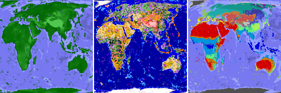
Explore a World You Know
TerraFirmaCraft meets real-world geography! 🌄
Ever dreamed of surviving and thriving in a world that feels truly familiar? A world where vast oceans separate iconic continents, majestic mountain ranges scrape the sky, and sweeping deserts give way to frozen tundras - all governed by TFC's deep and authentic survival systems?
TFC: Real World makes that dream a reality. ✨
This mod reshapes your TFC world using the very layout of our own planet. Experience the ultimate exploration adventure on a grand, believable scale, where every journey feels like charting undiscovered territory on Earth itself - complete with TerraFirmaCraft's signature realism and progression. ⛏️🌱
What This Mod Does
TFC: Real World transforms the foundation of your world - not the gameplay. All the beloved TFC mechanics, resources, and challenges remain perfectly intact. What changes is the stage on which you play. 🗺️
Instead of random generation, the world's continents, mountains, oceans, and climate zones are guided by real-world data. This creates a uniquely immersive and logical geography for your survival saga.
🧭 Key Experiences & New Rules:
- Sail Across Familiar Waters: Navigate vast oceans and coastlines that mirror Earth's great seas. ⛵
- Conquer Legendary Peaks: Trek through towering mountain ranges and descend into deep oceanic trenches. 🏔️
- Traverse Global Climates: Journey from lush equatorial rainforests, through arid deserts and vast grasslands, into temperate woodlands, all the way to the frozen poles - each with TFC's authentic seasonal effects. ☀️❄️
- Discover Logical Landscapes: Find volcanoes where tectonic forces would place them, and experience climate transitions that make geographical sense. 🌋
The core TFC experience is unchanged. I simply use map data to tell the game where to place these incredible landscapes, making every world feel coherent, vast, and ripe for exploration.
⚙️ Technical Details & Configuration
How It Works & Features 🏞️ The mod works by replacing TFC's default noise generators with data sampled from customizable map images. This integrates seamlessly, letting TFC's rich procedural detail fill in the local terrain. - **Continent & Ocean Layout:** Shaped by a world map image, creating Earth-like landmasses. - **Elevation & Depth:** Real altitude data creates realistic mountains, plains, and ocean floors. - **Volcanic Activity:** Hotspot maps guide the placement of TFC's volcanoes to tectonically plausible areas. - **Climate System:** A Köppen climate map defines temperature and rainfall belts (tropical, arid, temperate, continental, polar), which TFC's existing systems use to create biomes. - **Non-Intrusive:** No new blocks, items, or mobs. Uses Mixins to only redirect worldgen rules. - **Enhanced Canyon Biomes:** Optional config to make canyon biomes purely erosional, removing volcanic features (1.21.1 only). Configuration Guide 🛠️ **Important Version Notice:** This configuration guide applies to **TFC: Real World v4.0.3+ (1.21.1), v3.0.4+ (1.20.1), and v2.0.2+ (1.18.2)**. If you are using an older version, I strongly recommend updating to the latest version for access to these improved configuration options. Legacy versions use a different configuration system and are no longer supported with guides. All configuration is accessible directly from the **TFC world creation screen** for easy adjustment. Advanced users can also modify the config files manually. #### 📋 Map Profiles - **Map Profile**: Select which set of map images to use for world generation (e.g., Full World, Old World). The default profile contains all necessary Earth map data. #### 📍 Spawn Settings Choose where you start your adventure: - **Spawn Mode**: - `GEOGRAPHIC`: Spawn using real-world coordinates! Set a latitude and longitude. - `RANDOM`: A random location determined by the world seed. - `CLASSIC`: Use TFC's original coordinate-based spawning system. - **Geographic Spawn Center (Longitude/Latitude)**: When using `GEOGRAPHIC` mode, set the exact center of the area where you can spawn. The game will pick a suitable nearby location. #### 🎯 TFC Spawn Settings TFC's original coordinate-based spawning options (used in `CLASSIC` mode): - **Classic Spawn Center (X/Z)**: When using `CLASSIC` mode, these TFC options define the center point for spawning. - **Spawn Distance**: Maximum spawn radius from the spawn center. Applies to both `GEOGRAPHIC` and `CLASSIC` modes. #### 🌿 Biome Modifications - **Canyons Not Volcanic**: When enabled (default), removes volcanic rock and features from Canyon and Doline Canyon biomes, making them purely erosional landscapes. #### ⛰️ TFC World Parameters Fine-tune familiar TFC world generation values. - **Flat Bedrock**: If enabled, the bottom of the world is a single, flat bedrock layer. - **Finite Continents**: If enabled, the world has a limited number of continents surrounded by a vast, deep ocean (1.21.1 only). - **Continentalness**: Controls landmass size. Lower values = more fragmented land and islands. Higher values = larger, solid continents (if continents and altitude from map is disabled). - **Grass Density**: Affects the amount of grass coverage globally (1.20.1+). - **Temperature Constant**: A number representing the temperature for an entire world, where -1.0 is polar and 1.0 is tropical (if climate from map is disabled, 1.20.1+). - **Rainfall Constant**: A number representing the rainfall for an entire world, where -1.0 is arid and 1.0 is tropical (if climate from map is disabled, 1.20.1+). - **Temperature Scale**: The distance (in blocks) between the hottest and coldest climate zones (if climate from map is disabled). - **Rainfall Scale**: The distance (in blocks) between the wettest and driest climate zones (if climate from map is disabled). #### ⚠️ Critical Scaling Settings These two values are **crucial** for maintaining correct map proportions. They control how many Minecraft blocks represent the real-world data. - **Horizontal Scale**: The radius of the world map in blocks. - **Vertical Scale**: The height limit for terrain in blocks. **Important:** The **ratio between Horizontal Scale and Vertical Scale must match the original map data's aspect ratio**. If these values are set to disproportionate sizes, the world will appear **stretched or squashed**. The default values are correctly calibrated. #### 🌐 World Generation Modes Toggle which aspects of the world are shaped by real data. Disabling a mode will revert that feature to TFC's standard procedural generation. - **Generate Continents from Map**: Shapes landmasses and oceans using the world map. - **Generate Altitude from Map**: Creates realistic mountains, hills, plains, and ocean depth. - **Generate Hotspots from Map**: Places TFC's volcanoes in tectonically plausible areas. - **Generate Climate from Map**: Uses the Köppen climate map to create logical temperature and rainfall belts (tropical, arid, temperate, etc.). #### 💡 Quick Tips 1. **For an authentic Earth experience**, keep all four `Generate ... from Map` options enabled. 2. Use **Geographic Spawn** to start in a specific country or near famous landmarks. 3. **Do not change `Horizontal Scale` or `Vertical Scale`** unless you understand the map's proportions and want a deliberately distorted world. Advanced: Custom Map Profiles 🎨 This guide explains how to create custom map profiles for advanced users who want to generate worlds using their own geographic data. #### 🏗️ Map Profile Structure Map profiles organize all the map images needed for world generation. Each profile must have a `maps/` directory containing the required map files: ``` {namespace}/{profile_name}/ ├─ maps/ │ ├── continent.png │ ├── altitude.png │ ├── hotspots.png │ ├── koppen.png │ ├── temperature.png │ └── rainfall.png └── settings.json ``` Profiles can be placed in two locations: - **Mod JAR resources:** `data/tfc_real_world/profiles/{namespace}/{profile_name}/` - **External config directory:** `config/tfc_real_world/profiles/{namespace}/{profile_name}/` (or as ZIP files in this directory) External profiles take priority over JAR profiles with the same namespace and name. #### 🔧 Profile Settings (`settings.json`) Each map profile requires a `settings.json` file that defines the profile's configuration. All fields are optional and will use default values if omitted. **Display Settings:** - **Index** (Integer, default: `2147483647`): Display order in the profile selection list. Lower values appear first. - **Lang** (Object, default: `{}`): Localized display names for the profile. Keys are language codes (e.g., `"en_us"`, `"ru_ru"`), values are display strings. **Spawn Settings:** - **Spawn Center Longitude** (Double, default: `12.4964`): Geographic longitude for the default spawn center (Rome, Italy). - **Spawn Center Latitude** (Double, default: `41.9028`): Geographic latitude for the default spawn center (Rome, Italy). **Scaling Settings:** - **Horizontal Scale** (Integer, default: `40000`): The radius of the world map in blocks. - **Vertical Scale** (Integer, default: `20000`): The height limit for terrain in blocks. **Important:** The ratio between `horizontal_scale` and `vertical_scale` should match your map's aspect ratio to avoid stretching or squashing. **Map Boundaries:** - **West Edge Longitude** (Double, default: `-170.0`): Western edge of the map in degrees longitude. - **East Edge Longitude** (Double, default: `190.0`): Eastern edge of the map in degrees longitude. - **South Edge Latitude** (Double, default: `-90.0`): Southern edge of the map in degrees latitude. - **North Edge Latitude** (Double, default: `90.0`): Northern edge of the map in degrees latitude. **Projection:** - **Map Projection** (String, default: `"EQUAL_EARTH"`): Map projection type. Currently only `"EQUAL_EARTH"` is supported. #### 🖼️ Required Map Images All maps must be PNG format and have identical dimensions. Maps should use an equal-area projection (e.g., Equal Earth) to maintain proper proportions. **Continent Map (`continent.png`):** Defines landmass distribution and continental boundaries. Format: Grayscale PNG. Legend: `0` (black) = Ocean, `255` (white) = Land. This map shapes the basic layout of continents and oceans in your world. **Altitude Map (`altitude.png`):** Defines terrain elevation and ocean depth. Format: Grayscale PNG. Legend: `0-127` = Ocean depth (darker = deeper), `128-255` = Land elevation (brighter = higher). Creates realistic mountains, hills, plains, and ocean floors. Example values: `0` = Deepest ocean, `64` = Shallow ocean, `128` = Sea level (coastline), `192` = Hills, `255` = Highest mountains. **Hotspots Map (`hotspots.png`):** Defines volcanic hotspot locations and ages. Format: Grayscale PNG. Legend: `0` = No hotspot (age 0), `64` = Age 4 (oldest), `128` = Age 3, `192` = Age 2, `255` = Age 1 (youngest). Places TFC volcanoes in tectonically plausible areas. **Köppen Climate Map (`koppen.png`):** Defines climate zones using the Köppen climate classification system. Format: RGB Color PNG. Each climate type has a specific RGB color that must match exactly. Climate types and their RGB colors: - **AF** (Humid Tropical): `(0, 0, 220)` - **AS** (Tropical Dry/Wet): `(0, 100, 240)` - **AW** (Tropical Wet/Dry): `(0, 150, 220)` - **AM** (Tropical Monsoon): `(40, 80, 200)` - **BWH** (Hot Desert): `(210, 0, 0)` - **BSH** (Hot Semi-Arid): `(210, 120, 0)` - **BWK** (Cold Desert): `(200, 80, 80)` - **BSK** (Cold Semi-Arid): `(200, 120, 60)` - **CSA** (Coastal Subtropical): `(250, 250, 0)` - **CSB** (Coastal): `(180, 180, 0)` - **CSC** (Cold Coastal): `(120, 120, 0)` - **CWA** (Monsoonal Subtropical): `(100, 240, 130)` - **CWB** (Monsoonal Temperate): `(80, 210, 120)` - **CWC** (Cold Monsoonal Temperate): `(70, 160, 110)` - **CFA** (Oceanic Subtropical): `(170, 240, 90)` - **CFB** (Oceanic): `(140, 200, 80)` - **CFC** (Cold Oceanic): `(110, 170, 70)` - **DSA** (Coastal Continental): `(190, 20, 190)` - **DSB** (Cold Coastal Continental): `(160, 20, 180)` - **DSC** (Coastal Subarctic): `(130, 20, 170)` - **DSD** (Coastal Cold Subarctic): `(100, 20, 160)` - **DFA** (Continental): `(40, 190, 190)` - **DFB** (Cold Continental): `(30, 170, 170)` - **DFC** (Subarctic): `(20, 150, 140)` - **DFD** (Cold Subarctic): `(10, 130, 110)` - **DWA** (Monsoonal Continental): `(80, 80, 220)` - **DWB** (Cold Monsoonal Continental): `(70, 70, 190)` - **DWC** (Monsoonal Subarctic): `(60, 60, 160)` - **DWD** (Cold Monsoonal Subarctic): `(60, 60, 130)` - **ET** (Tundra): `(190, 190, 190)` - **EF** (Polar): `(80, 80, 80)` **Temperature Map (`temperature.png`):** Provides temperature data used in conjunction with the Köppen map. Format: Grayscale PNG. Legend: `0` (black) = Coldest, `255` (white) = Hottest. Each Köppen climate zone interprets grayscale values within its own temperature range, so higher brightness indicates warmer temperatures for that specific climate type. **Rainfall Map (`rainfall.png`):** Provides rainfall data used in conjunction with the Köppen map. Format: Grayscale PNG. Legend: `0` (black) = Driest, `255` (white) = Wettest. Each Köppen climate zone interprets grayscale values within its own rainfall range, so higher brightness indicates more rainfall for that specific climate type. #### ✅ Best Practices 1. **Consistency:** Ensure all maps align properly - continents should match altitude, climate should match temperature/rainfall patterns. 2. **Smooth Transitions:** Use gradual gradients rather than sharp boundaries to avoid visual artifacts in the generated world. 3. **Sea Level:** In the altitude map, keep the sea level boundary (128) consistent with your continent map - ocean areas should have values below 128. 4. **Color Accuracy:** For the Köppen map, use the exact RGB values provided. Even small deviations will cause the mod to use the nearest matching climate type. 5. **Testing:** Test your maps with a small world first to verify proportions and alignment before creating large-scale maps. 6. **Map Dimensions:** All maps in a profile must have identical width and height. Use an equal-area projection to maintain proper proportions across the entire map. #### 🏝️ Example: Creating a Simple Island Map Here's a minimal example for creating a basic island map profile: 1. **Continent Map:** Create a 1280x640 grayscale image with most of the map at `0` (ocean) and a circular island in the center at `255` (land). 2. **Altitude Map:** Create a matching 1280x640 grayscale image with ocean areas at `64` (shallow ocean), island edges at `128` (sea level), and island center at `200` (hills). 3. **Hotspots Map:** Create a 1280x640 grayscale image with most areas at `0` (no volcanoes) and a small hotspot on the island at `192` (age 2). 4. **Köppen Map:** Create a 1280x640 RGB image using `(140, 200, 80)` for CFB (Oceanic climate). 5. **Temperature Map:** Create a 1280x640 grayscale image with a gradient from `120` (cooler) at the edges to `180` (warmer) at the center, representing temperature variation across the island. 6. **Rainfall Map:** Create a 1280x640 grayscale image with a gradient from `140` (drier) at the edges to `200` (wetter) at the center, representing rainfall variation across the island. 7. **Settings:** Create `settings.json` with `horizontal_scale` = `40000` and `vertical_scale` = `20000` to match the 2:1 aspect ratio of the maps. Note that due to the 2:1, a circular island in your map will appear as an oval in the generated world. All six maps must be exactly 1280x640 pixels and saved as PNG files in the profile's `maps/` directory. Roadmap 🗓️ 1. A similar mod for vanilla Minecraft. 2. A version with a larger and more detailed world map. 3. Port the mod to TFC 1.12.2 (though this will be challenging).📎 Links
If you have suggestions or want to report a bug, please create an issue and I will definitely respond.
Dive into the ultimate survival exploration mod for TerraFirmaCraft. Start your journey on a world that feels like home, yet is filled with endless discovery. 🚀
请登录后举报
请 登录 后赞助作者。
暂无评论,抢个沙发吧~